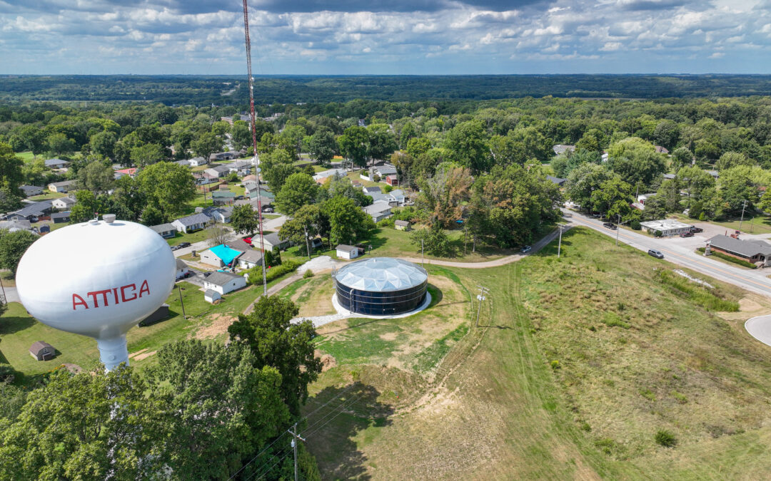
Lawrence Residences at Lawrence Village

Lawrence, IN

Residence at Lawrence Village

HWC provided site design and drainage services to Weekley Homes for this new housing community located within the Fort Harrison Reuse Authority’s site at 59th Street and Post Road in Indianapolis, Indiana. The Residences at Lawrence Village sit on approximately 9.2 acres within the former Fort Benjamin Harrison military base that is now a mixed-use community. The new housing community is a mix of 74 single-family energy-efficient traditional and cottage style homes in a master-planned community near healthcare facilities and Ben Harrison YMCA as well as within walking distance to Fort Harrison State Park and Fort Golf Course.

The design is compliant with the Lawrence Village at the Fort PUD, City of Lawrence Standards, and the City of Indianapolis Standards. Construction on the project began in the Spring of 2015.

Scottsburg US 31 Road Diet

Scottsburg US 31 Road Diet

Scottsburg, IN

US 31 Road Diet

HWC performed surveying services at the start of the project to help HWC’s transportation team better understand the scope of the project as they provided roadway design, utility coordination, traffic signal planning, and public information meeting coordination services for INDOT’s US 31 Road Diet project. 

The need for this project is to address a number of rear-end traffic collisions while enhancing road safety and the overall quality of traffic flow. US 31 is a four-lane urban principal arterial. Currently, there are no designated lanes for both northbound and southbound vehicles turning left along US 31 in Scottsburg, which has led to this increase of rear-end traffic collisions.

The survey department provided route survey services, supplemented by aerial mapping. These deliverables aided in HWC’s collaboration with INDOT and the City of Scottsburg to develop the road diet concept and establish the project limits. US 31 was converted from four travel lanes (two lanes in each direction) to a three-lane section (one lane in each direction with a two-way left turn lane) from SR 56 to York Road (0.75 miles). The two-way left turn lane will allow motorists to make left hand turns without impacting traffic in the travel lanes of US 31, reducing the number of rear end collisions. US 31 was milled and resurfaced to remove all existing pavement markings and new thermoplastic pavement markings were installed to delineate the three-lane roadway section.

The construction cost of the project was $563,000.

Jeffersonville River Ridge Development Office Park Phase 1 Entrance

Jeffersonville River Ridge Development Office Park Phase 1 Entrance

Jeffersonville, IN

River Ridge Development Office Park Phase 1 Entrance

HWC completed a topographic and utility survey for the project site of the River Ridge Office Park entrance. HWC has also performed survey work for utility infrastructure extensions for the surrounding areas. HWC has been actively preparing ALTA/land title survey, utility surveys, and route surveys within the River Ridge Commerce Center area since 2015.  

Rush County Solar Project

Rush County Solar Project

Rush County, IN

Solar Project

HWC prepared ALTA/NSPS land title surveys over approximately 2,200 acres of land in Rush County for the potential development of a solar farm. Aerial LiDAR data was also incorporated into the surveys to prepare combined boundary and topographic survey drawings to support the design and layout of solar panels, service roads, and electric lines for project development. In addition to our survey services, our interdisciplinary team provided vegetative buffering plans, drainage analysis, planning and zoning coordination advisory services, and community and local government relations to the project.  

New Albany Ohio River Greenway

New Albany Ohio River Greenway

New Albany, IN

Ohio River Greenway

Working closely with the City of New Albany, HWC recently completed the survey services required for the design and bidding of three projects along the New Albany Shoreline. These projects include additional trail mileage along the Silver Creek kayak launch at the Spring Street bridge, and an extension of the Ohio River Greenway trail to the River Recreation site, a new riverfront nature park currently under design. 

HWC provided the design teams with drone data, orthophotography, and bathymetric surveys to provide a detailed area survey.